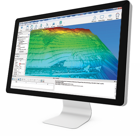
Stonex Cube-a 3D v7.x is an advanced GNSS 3D survey and modelling software designed to transform field data into accurate point clouds, meshes, and 3D models. Built for modern surveying workflows, it integrates seamlessly with Stonex GNSS receivers equipped with imaging capabilities, enabling fast and efficient spatial data capture.
Designed for professionals in construction, civil engineering, mining, and infrastructure, Cube-a 3D allows users to collect, process, and visualise complex environments directly from the field. By combining GNSS positioning, IMU technology, and photogrammetry, the software delivers precise results even in challenging or hard-to-access areas.
🚀 Advanced 3D Surveying Capabilities
Cube-a 3D enables the creation of high-quality point clouds and mesh models from images and video captured in the field. This allows surveyors to generate accurate digital representations of real-world environments without the need for traditional, time-consuming methods.
The software supports photogrammetry-based workflows, extracting spatial data from multiple images to calculate precise coordinates and geometry. This makes it ideal for capturing complex structures, terrain, and infrastructure.
📍 Measure Inaccessible Areas with Confidence
One of the standout features of Cube-a 3D is its ability to measure inaccessible or hazardous locations. Using image-based data capture, surveyors can safely collect measurements from a distance, reducing risk while maintaining accuracy.
This capability is particularly valuable for:
- High walls and stockpiles
- Dangerous construction zones
- Infrastructure inspections
- Confined or restricted areas
🔄 Seamless GNSS Integration
Cube-a 3D integrates directly with Stonex GNSS receivers, combining precise positioning data with visual information. This ensures that all 3D models and measurements are accurately georeferenced, allowing for immediate use in design, analysis, and reporting.
The software also works alongside other Cube-a modules, enabling a unified workflow across:
- GNSS surveying
- Total station measurements
- GIS data collection
- 3D modelling and processing
⚡ Efficient Field & Office Workflows
With Cube-a 3D v7.x, users can process data both in the field and in the office, providing flexibility depending on project requirements. Real-time or near real-time processing allows for immediate validation of results, reducing rework and improving productivity.
The intuitive interface ensures that even complex 3D tasks can be completed efficiently, helping teams save time and increase output.
⚙️ Key Features
- Advanced GNSS 3D survey and modelling software
- Creation of point clouds and mesh models
- Supports photogrammetry workflows
- Enables measurement of inaccessible areas
- Seamless integration with Stonex GNSS receivers
- Real-time and post-processing capabilities
- Intuitive interface for efficient field use
🌍 Applications
- 3D surveying and modelling
- Construction and site analysis
- Infrastructure and civil engineering
- Mining and quarry surveys
- Environmental and land mapping
- Asset inspection and monitoring
🔌 Why Choose Stonex Cube-a 3D v7.x?
The Cube-a 3D software provides a powerful solution for surveyors looking to move beyond traditional methods. By combining GNSS precision with 3D modelling and photogrammetry, it enables faster, safer, and more accurate data collection.
Whether you’re working on construction sites, infrastructure projects, or complex terrain, Cube-a 3D delivers the tools needed to capture and process spatial data with confidence.